
A baseline foodshed analysis shows the estimated food production potential of a specific area’s productive land relative to the food needs of its population. A foodshed is a geographic area (typically within the boundaries of a district or region) that encompasses all the sources of food that are grown within that area. In an ideal world, a localised foodshed would also supply the population or community within that foodshed. Due to the complicated nature of a globalised food chain, this is no longer the story.
The idea behind a foodshed analysis is to identify the potential gaps or weaknesses of the current foodshed, such as a deficit of particular food types required to feed a population or a surplus of a particular food type that is well known to be exported, therefore bringing in wealth but potentially not food resilience.
Therefore, a baseline foodshed analysis is a concept used to map the production of food within a specific geographic area and calculate the requirements for food for the population within that same area. The results provide a deeper understanding of the types and quantities of surplus food that is produced or that is lacking in the specific area. The foodshed analysis alone does not provide the detail of where the food goes (distribution); a food system analysis is required for that.
Whirika have been contracted to produce a foodshed analysis for the Waikato region as part of out work to create a baseline of the Waikato kai system. The key steps in the foodshed analysis are:
Stage 1: Baseline foodshed analysis for the Waikato Region 2024
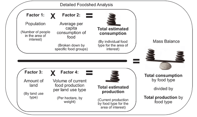
Creating a detailed foodshed analysis provides greater depth of understanding of the amount of food that is produced within the region versus the amount of food that is required to feed the population of the region
A detailed analysis of the average per capita consumption of food, population, existing land use and estimated food production occurring within the foodshed provides a clear understanding of the types and quantities of food that is produced (maybe in surplus) or that is lacking (not grown at all) within the region.
Stage 2: Compare changes to food producing land 2002 -2024
Whirika will compare the changes to the food producing land and the population over the 22-year period from 2002 and 2024 for the Waikato District, Waipa District and Hamilton City only. This methodology was used to produce a regional foodshed for the Wellington region in early 2024. This report can be seen here.
